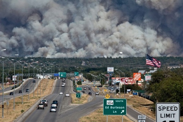
Bastrop State Park is gone. Close to a thousand homes are gone. People have died. As of this afternoon, they only had the fire partially contained. This is really, really bad.

On Tuesday I drove to Houston which normally takes me thru Bastrop. The photo above is a view of the city as you come in from the west. Highway 71 descends from this spot down to the Colorado River and then up out of the valley on the far side. That rise is visible as trees in the distance. And over that hill is Bastrop State Park.
That park was my first introduction to Central Texas back in 1979. Alan was driving four of us to Austin from our summer jobs in Houston, and he told us about Bastrop and the park and about Lost Pines, about how this island stand of Loblollies was an isolated remnant of a great forest that covered this area long ago.
On Tuesday, of course, the highway was closed. So I bypassed Bastrop west and south of the fire, taking the two legs of a triangle instead of the hypotenuse.
The wind was blowing out of the north and pushed the plume across my route.
I entered the smoke near Lockhart as I was driving south. 15 miles later, in Luling, I turned east on Interstate 10 and only then entered the plume in earnest. Visibility was drivable, but the smoke was thick, and my windows were shut. At 65 mph, it took me 30 minutes to emerge on the other side of the plume.
Enough to make a grown man cry.
photo credit: Unknown. Sent to me by a friend. Don’t know where he got it.